 Cloud & Business Apps
 Cybersecurity
 Data & AI
 IoT & Connectivity
 Industry
 Health
 Banking and Finance
 Public Sector
 Retail
 Tourism and Leisure
 Transport & Logistics
 Energy & Utilities
 Smart Cities


Monitoring crowd levels at major events with mobile network data: the Venida del Rocío pilgrimage
When managing major events such as concerts, sporting events or large gatherings of any kind, emergency services need to know how many people are in each area and how those numbers change as the event unfolds.
In this article, we explain how Smart Steps Near Real Time works, Telefónica's service for estimating crowd levels from mobile network data, and how it was used during the 2026 Venida de la Virgen del Rocío, the traditional transfer of the Virgin of El Rocío from El Rocío to Almonte in Andalusia, Spain.
The challenge: monitoring crowd levels during the 2026 Venida del Rocío
The Venida takes place every seven years. On 19 and 20 August 2026, the image of the Virgin of El Rocío was taken from the village of El Rocío to Almonte along the approximately 15-kilometre Camino de los Llanos, as part of a pilgrimage that drew large numbers of pilgrims and devotees.
For the occasion, the Emergency Service of the Regional Government of Andalusia activated the “Plan Venida”, which included a large-scale special security operation, together with coordination and emergency arrangements organised by Almonte Town Council, the Regional Government of Andalusia and the State security forces to ensure safety during the transfer of the Virgin of El Rocío from her sanctuary in the village of El Rocío to the town of Almonte.
To support the operation, the Emergency Service used our Smart Steps service to provide information on crowd density along an extensive linear route, with latency low enough to support decision-making during the event.
■ One of the main advantages of this mobile network-based system is that it is well suited to large events spread over extensive areas because it does not require sensors or cameras to be installed along the route, instead using the telecommunications infrastructure already in place.
The mobile network makes it possible to estimate crowd levels along the route without installing sensors or cameras.
How mobile network data is used to estimate the number of people in each area
Mobile phones that are switched on and within coverage communicate continuously with the mobile network's antennas. Each antenna has a theoretical coverage area, known as a cell, whose size ranges from hundreds of metres to several kilometres depending on network density, which is higher in urban areas than in rural ones. Probes on the Movistar network collect these events, which fall into two categories:
- Active events: generated by user interaction, such as a call, message or data use, or by a handover when the user moves between cells while the device is active.
- Passive events: generated automatically by the network, such as changes in cell, LAC or network technology. These occur mainly when the user is moving and make it possible to include devices with no voice or data activity in the sample, avoiding a bias towards heavy users.
If the cell were the only reference, spatial accuracy would be limited to the coverage radius of the antennas, which in rural environments such as the one in this use case can extend for tens of kilometres.
To improve this accuracy, the service uses Timing Advance technology, through which the network measures the signal's round-trip time between the device and the antenna. The longer this takes, the further away the device is considered to be. This makes it possible to define concentric rings around the antenna and assign each device to one of them. For example, in a cell with a theoretical range of 5 km, accuracy improves from 5 km to 234 m; in a 2 km cell, it improves from 2 km to 78 m.
The subsequent processing involves three steps:
- Anonymisation: each mobile line is replaced “on the fly” with an obfuscated, irreversible identifier that remains persistent over time, using double hashing, transformation, categorisation and aggregation.
- Extrapolation: to estimate the total number of people from the devices observed on Movistar's network, calibration algorithms are applied using external data sources.
- Aggregation: the results are aggregated into an H3 hexagonal grid, never refer to groups of fewer than 15 individuals (K-anonymity) and are reported as ranges.
Network data is anonymised, extrapolated and aggregated to estimate crowd levels by area.
Crowd maps, alerts and historical data with Smart Steps
Based on the data processing described above, Smart Steps Near Real Time provides an interactive interface that allows emergency operators to visualise crowd concentrations in each preselected area of interest.
Among other features, the service provides:
- A crowd heat map using hexagons with a spatial resolution of approximately 75 metres.
- Updates every 15 minutes, with an average latency of around 45 minutes.
- Custom areas defined by the customer, showing estimated numbers of people, density levels and changes compared with the previous hour.
- The ability to visualise historical data: for comparison with non-event days and to track changes over time.
- Historical hourly density data for selected areas.
- Percentage changes in crowd levels, showing increases and decreases, with alerts for sharp increases.
- 3D visualisations of crowd-level KPIs in custom areas.
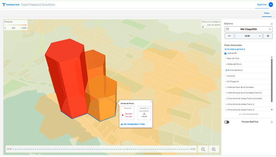
Crowd maps and alerts help track concentrations of people and how they change over time.
Monitoring crowd levels along the route to Almonte
With the tool open throughout the event, the teams running the operation could follow developments almost minute by minute.
At around 15:30 on 19 August, the Virgin left the shrine at El Rocío, and the map showed how the concentration of people in the village gave way to steady movement along the route: the procession advanced along the road towards Almonte, with the areas of highest density moving with the image until it reached the Parish Church of Nuestra Señora de la Asunción in the early hours of the following morning. The image remains there until, a few months later, it is returned to its usual home at the Sanctuary of Nuestra Señora del Rocío in the village of El Rocío.
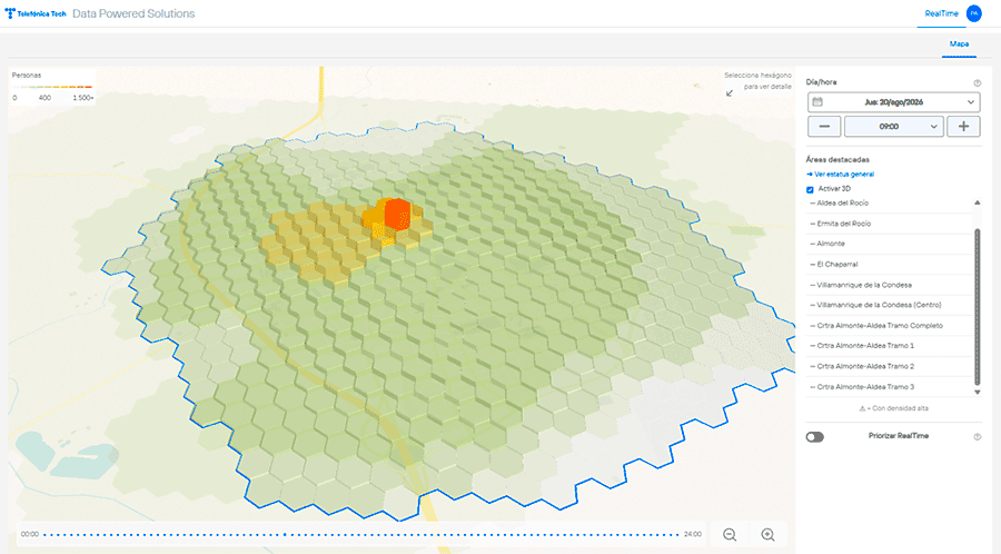
■ This overall view allows emergency teams to prioritise resources, identify crowd build-ups and make decisions based on data received within a short timeframe.
An overall view of crowd levels helps identify build-ups and prioritise emergency resources.
The same service for other events, situations and sensitive locations
The El Rocío case is an example. Emergency services, local police forces and event organisers can use the same service for:
- Pilgrimages, local festivals, fairs and processions.
- Concerts, sporting events and marathons.
- Demonstrations and large gatherings in open spaces.
- Monitoring sensitive locations such as stations, ports, airports and border crossings.
■ With no civil works or additional devices to install, and with data available wherever there is mobile coverage, Smart Steps Near Real Time gives emergency teams an objective, up-to-date view of crowd levels from the planning stage through to the end of the event. More information →
Smart Steps makes it possible to monitor crowd levels at different types of events without installing additional devices.