 Hybrid Cloud
 Cybersecurity
 Data & AI
 IoT & Connectivity
 Industry
 Health
 Banking and Finance
 Public Sector
 Retail
 Tourism and Leisure
 Transport & Logistics
 Energy & Utilities
 Smart Cities
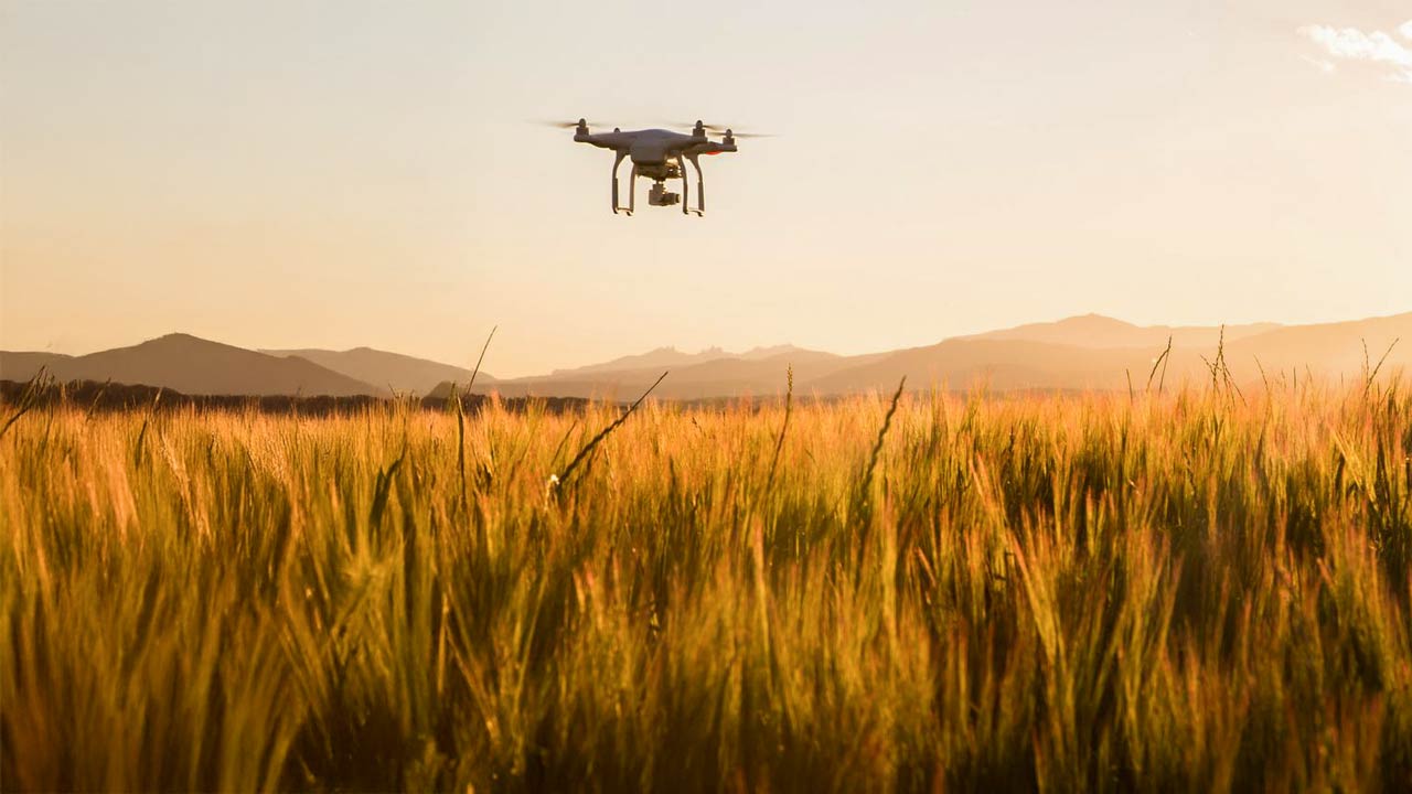

Drones, AI and IoT in precision agriculture: innovation across the phenological cycle
Precision agriculture has undergone a profound transformation in recent years, driven by the adoption of advanced technologies, with drones playing a particularly prominent role. Although they first entered the market in the 2010s, adoption was initially slow due to technological limitations, high operational costs and restrictive regulations.
Today, that scenario has changed. Technological maturity, lower costs and increasing digitalisation have consolidated drones as essential tools for acting precisely at critical points of the phenological cycle.
But… what has really driven their adoption? What capabilities do they offer beyond aerial imagery? What are the key factors for integrating them effectively into farm operations? And above all, what tangible benefits do they deliver?
We explore the answers to these questions by analysing the role of drones as strategic allies for more efficient, sustainable and connected agriculture.
Key drivers behind the evolution and adoption of drones
Several factors have accelerated drone adoption in agriculture, transforming them from a tech curiosity into key tools in precision farming.
Hardware and software advances
Agricultural drones have undergone major technical improvements. They now include multispectral sensors, thermal and high-resolution optical cameras. In addition, they've improved autonomy, payload capacity and resistance to adverse conditions, enabling them to cover larger areas and apply inputs (pesticides, fertilisers) more efficiently.
In parallel, software has advanced significantly. Today’s platforms can automatically process collected data, generate vegetation index maps and enable autonomous flight planning.
The incorporation of AI enables agronomic decision-making, transforming the drone from a descriptive tool into a predictive one.
Regulatory framework evolution
The regulatory landscape around drone operations has evolved significantly in recent years, with changes aimed at simplifying administrative procedures and expanding operational possibilities in rural environments. Key developments include the authorisation of new flight zones and the implementation of more flexible airspace management, especially in areas away from urban centres.
Before launching a drone-based project, it is essential to consult local regulations and airspace management platforms to understand applicable flight restrictions and required permits.
Improved rural connectivity
Digitalisation in rural environments is often linked to connectivity challenges. The rollout of more robust telecom networks and improved connectivity in rural areas has been key to enabling advanced drone applications.
Thanks to these improvements, drones have moved from future promise to present reality in agriculture, opening the door to new ways of managing and optimising crops.
Drone applications and capabilities
Drones offer multiple applications in agriculture, adapting to each crop's specific needs throughout the phenological cycle. This article focuses on multirotor drones, a highly versatile category due to their manoeuvrability, precision and ease of deployment.
Within this category, we distinguish two main types based on their capabilities: spraying drones and inspection and analysis drones.
Both can operate individually or together, combining functionalities to intervene at key crop moments.
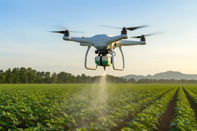
Spraying with drones
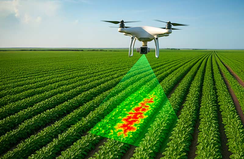
The use of drones to apply plant protection products enables targeted and efficient intervention.
Thanks to their ability to operate in hard-to-reach areas and act within narrow time windows, drones offer an effective solution for ensuring both uniform and specific treatments, while minimising input use and reducing environmental impact.
In 2024, drone usage helped save 210 million tonnes of water and 47,000 tonnes of fertiliser across agricultural operations.
New models can also adjust parameters like flow rate, altitude and flight speed based on crop phase and vegetation density. The estimated application rate is 10 hectares per hour, though this depends on terrain and weather conditions.
The table below compares drone and tractor-based spraying:
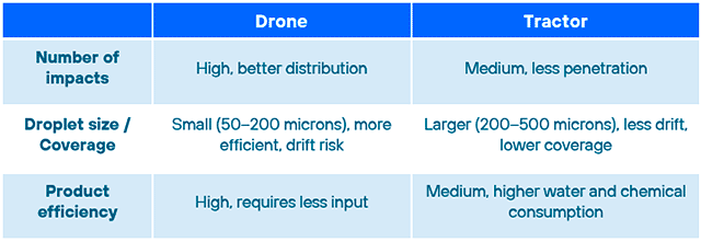
The results achieved with drones are largely due to the vortex effect, a phenomenon caused by the downward airflow from their rotors. This significantly improves agrochemical penetration and distribution, enabling more uniform coverage, even in dense vegetation.
■ Spraying drones and the digital field log
A key feature of drone integration into the agriculture 4.0 ecosystem is their ability to automate data capture and upload it to the digital field log.
This enables automated, accurate records of:
● Treatment date and time
● Product used
● Applied dosage
● Area treated
● Operator and equipment ID
This ensures regulatory compliance, and also significantly improves traceability, agronomic planning and overall operational efficiency, avoiding duplication and saving farmers time.
Multispectral data analysis
The multispectral camera is a key technology in agricultural drones, capturing images across various bands of the electromagnetic spectrum—not just the visible range. These cameras detect radiation in wavelengths such as near-infrared (NIR), mid-infrared (MIR) and thermal infrared (TIR), making them powerful tools for agronomic analysis.
The collected data is processed through an agricultural analytics platform capable of cross-referencing information with over 100 vegetation indices.
Vegetation indices are visual representations of plant reflectance, combining two or more wavelengths. Depending on the type of reflectance, they typically fall into these categories:
- Green reflectance: linked to plant vigour and ground cover.
- Light-use efficiency: measures a plant's ability to absorb and utilise light.
- Foliar nitrogen: useful for optimising fertilisation.
- Carbon tracking: reflects photosynthetic activity and growth.
- Pigmentation: shows levels of chlorophyll, carotenoids, or anthocyanins.
- Water content: identifies areas with water deficit or excess.
Each index offers a unique perspective, and when combined, they enable a comprehensive analysis of crop health, development and productivity.
■ The power of combining satellite imagery and drones
Many of these indices are also applied to satellite imagery—particularly the NDVI (Normalised Difference Vegetation Index).
It’s important to highlight the complementary nature of drones and satellites. While satellites provide large-scale, continuous monitoring, drones enable high-precision, targeted interventions.
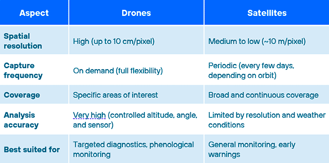
Together, they enable a scalable and accurate crop monitoring strategy, where satellites act as the “general radar” and drones serve as the “precision magnifier”.
Yield prediction
As mentioned earlier, AI has had a major impact on agricultural forecasting models, especially in early detection of disease, pests, and yield estimation.
These predictive models are powered by integrating data from multiple sources: farm history, weather data and real-time inputs from sensors, drones and satellites. This advanced layer of analysis and interpretation completely redefines the role and value of drones in the field.
Agricultural drones can reduce pesticide use by up to 85%, water consumption by 40% and increase crop yields by 15–20%, thanks to early detection of nutrient deficiencies.
Keys to a successful drone project in agriculture
Deploying drones on a farm isn't just about adopting new tech —it's about integrating it effectively into the farm’s operating and production model. The following are key success factors for implementing drone-based projects:
Start with a pilot
Launching a small-scale pilot (limited area, crop, functionality) allows for validation under real conditions, identifies barriers, and reduces risk for progressive, context-specific deployment.
Analyse results and scale strategically
After the pilot, it’s essential to evaluate results by measuring treatment efficiency, input savings, decision-making improvements, and ease of use. This informs a data-driven scaling strategy aligned with agronomic needs and available resources (financial, human, technological).
Integrate with existing systems
Combining drone data with in-field IoT sensors (e.g. weather stations, soil moisture, nutrient meters) enriches agronomic analysis. This real-time data integration enables more precise and automated crop management.
■ IoT connectivity, especially in rural areas, is key to ensuring continuous data transmission to cloud platforms, where it’s processed and visualised to support decision-making.
Choose the right adoption model
Different adoption models are available, and choosing the right one depends on the farmer’s profile, farm size and project goals:
- Drones-as-a-Service: Ideal for farms looking to avoid large upfront investment or equipment management. Includes drone, pilot, data analysis and result delivery. Offers flexibility and access to the latest technology.
- Equipment purchase: Recommended for large farms or cooperatives with trained staff or plans to professionalise drone usage. Enables greater operational control.
Conclusion
Drones have evolved from mere data capture devices to strategic components of the agriculture 4.0 ecosystem. Their evolution reflects the need for more efficient, sustainable and automated production models.
At Telefónica Tech our proposition rests on two key technological pillars:
- Advanced connectivity: Solutions tailored to rural environments, including mobile networks, extended land coverage and satellite connectivity. This ensures secure, uninterrupted data transmission, even in remote areas without traditional network infrastructure.
- Technology integration: Enabling interoperability across diverse data sources (drones, IoT sensors, satellite imagery and cloud platforms), ensuring scalable, unified information management.
By combining these capabilities, we unlock the full potential of drones in key agricultural applications such as automated spraying, remote crop monitoring and advanced agronomic forecasting, helping to:
- Optimise agricultural input usage (water, fertilisers, pesticides), reducing costs and environmental impact.
- Improve treatment accuracy and timing using real-time geospatial data models.
- Detect issues early (pests, diseases, nutrient deficiencies), enabling more effective intervention.
- Boost yield and crop quality through tighter technical control of the growing cycle.
- Integrate multi-source data into analytics and visualisation platforms to support agronomic decision-making.
- Lay the groundwork for autonomous farming, powered by cyber-physical systems and remote asset management.
The technology architecture provided by Telefónica Tech enables these solutions to scale in real-world production environments with guaranteed service, secure data transmission and ongoing support. In this way, we drive an effective transition towards a more digital, resilient and results-oriented agricultural model.